
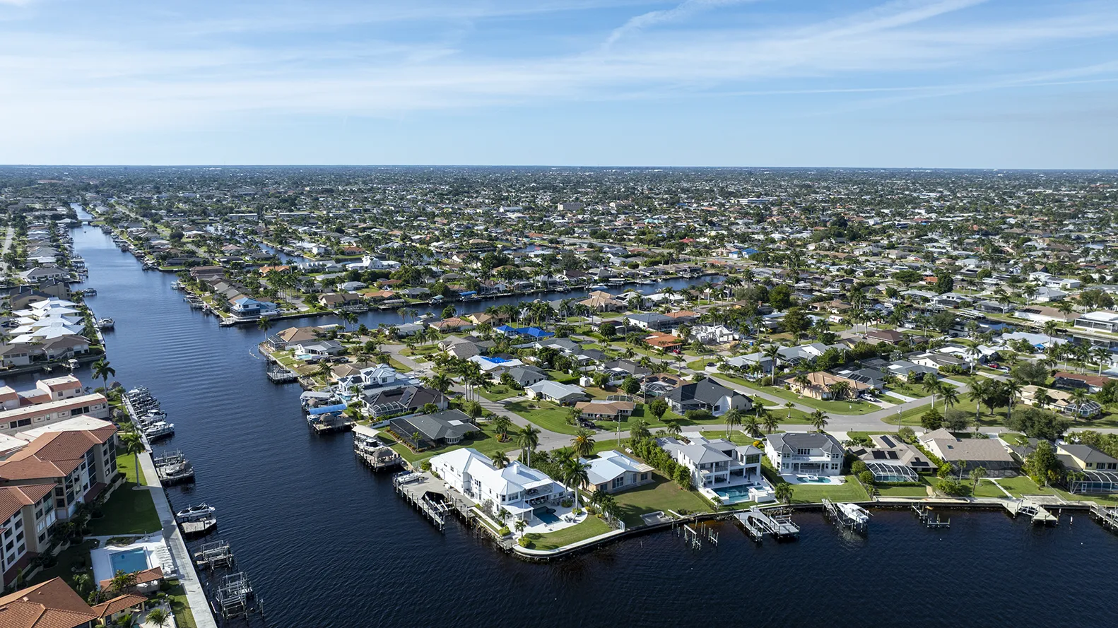
Cape Coral Canal Map: See the Route to Open Water Before You Buy
Tap any canal to trace its real route to open water, the fixed bridges you would pass under, and the gulf-access classification the City gives it. Built from the City of Cape Coral's own records, not a listing's promise.
Gulf access, bridges, and depth for every Cape Coral canal.
You will see the gulf-access classification, a traced route to open water with every fixed bridge and the idle time, the storm weirs on record, and the canal depth where surveyed. Freshwater canals trace their run to the neighborhood lake, and you can turn on public boat ramps and fuel docks. Built from the City's own records: 960 canals, 159 bridges, and every recorded weir. It is a smart starting point for the conversation, not a survey, so confirm the real route, bridges, and depth on the water before you make an offer.
Reference data only, not for navigation, and accuracy varies. A starting point for the conversation, not a survey. Verify canal classification, every bridge on the route, canal depth and width, and gulf access with a licensed surveyor, a marine contractor, and the City before making an offer.
In Cape Coral, "gulf access" means four different things.
Cape Coral has more canal frontage than any city in the country, and the label on a listing can hide big differences in price, insurance, and how you actually use the dock. Here is what the terms mean. This map shows the City's canal classification and recorded structures; confirming true gulf access, including every bridge on the way out and the depth of the water, happens on the ground.
Connected to a spreader system (SW A–E)
A saltwater canal that feeds one of Cape Coral's gulf-access systems. Reaching open water may still require passing under fixed bridges on connecting canals, so the route and clearances have to be checked end to end.
Fixed bridges set the ceiling to check
The lowest fixed bridge on the route to open water is the clearance to check against your air draft. City figures are approximate reference values, not tide-specific measurements. Confirm the number against your hardtop and antennas at high tide.
Behind a weir, no boat route out
A freshwater canal held back by a weir for water management. Excellent for kayaks, fishing, and quiet frontage, but there is no navigable boat route to the Gulf. Typically valued differently from gulf-access frontage; ask us for recent comparables.
Not on a mapped canal
The address does not sit on a mapped Cape Coral canal, or sits on a lake or basin outside the gulf-access network. We confirm frontage and access on the ground before you write an offer.
Ten things to check before you buy a Cape Coral waterfront home.
A canal map answers the first question. These are the ten checks that decide whether a specific dock actually works for your boat and your budget. We walk every one of them with you before an offer.
Confirm the City's classification. Saltwater feeds the gulf-access systems; freshwater sits behind a weir with no navigable route out.
Verify the full navigable path across connecting canals and confirm every fixed bridge on the way, not just the one behind the house.
Depth at low tide and canal width decide what draft and length can navigate and turn. City GIS does not carry a verified depth for every canal.
Air draft (height with hardtop and antennas) is checked against the lowest bridge at high tide; water draft against canal depth at low tide.
Age, material, cap condition, and any bowing or cracking. Seawall replacement is one of the largest waterfront surprises.
Lift weight rating, dock and lift permits on file with the City, and whether existing structures are permitted and conforming.
Power lines and other overhead obstructions between the dock and open water can limit air draft more than any bridge.
How long it actually takes to idle out to open water through no-wake zones, which shapes day-to-day use as much as the distance.
FEMA flood zone, elevation, and the insurance picture move the true cost of a waterfront lot. Check the flood zone and run the cost of owning a home.
Seasonal water quality, discharges, and conditions that affect boating and fishing on a given canal system.
Cape Coral canal map and gulf access, answered.
01What is the difference between direct and indirect gulf access?
Direct gulf access reaches open water with no fixed bridge in the way, so any air draft passes at any tide.
Indirect, or bridged, gulf access still reaches the Gulf but passes under one or more fixed bridges on the route, and the lowest bridge sets the height your boat can clear. On the map above, the route to open water shows every bridge you would pass on the way out.
02Is my Cape Coral canal saltwater or freshwater?
The City of Cape Coral classifies every canal as either saltwater or freshwater.
Saltwater canals feed the spreader gulf-access systems; freshwater canals sit behind a weir with no boat route to the Gulf. Search the address on the map above to see the City's classification for that canal.
03What bridge clearance do I need in Cape Coral?
Your air draft, the boat's height with hardtop and antennas, has to clear the lowest fixed bridge on the route out.
The map lists each bridge's City-recorded clearance, which is an approximate reference value, not a tide-specific measurement. Confirm the number against your own boat at high tide before you rely on it.
04What is a spreader canal and a weir?
A spreader system connects Cape Coral's saltwater canals; a weir is the low structure that seals off the freshwater ones.
The saltwater canals connect through spreader systems (SW A through E) that discharge to the Caloosahatchee and the Gulf. A weir is a low water-control structure that holds back freshwater canals, blocking any boat route between the freshwater side and the saltwater, gulf-access side.
05Does this map guarantee a home has gulf access?
No. Treat the map as the first step, not a survey.
It shows the City's canal classification and the way out to open water as a starting point. It does not measure how deep the water is, how low a bridge sits at high tide, or whether a canal has been dredged, so it cannot confirm that a specific boat can make the trip.
06How do I verify gulf access before making an offer?
Confirm the full route, every bridge, the canal depth and width, and the seawall before you write the offer.
Verify those with a licensed surveyor and a marine contractor, and check the flood zone and cost of ownership. We walk every step with you before you commit.
Talk with a Cape Coral gulf-access agent
We confirm the canal, bridges, and depth before you write the offer.
Send us the address and get a Cape Coral gulf-access specialist on the phone. We verify the real route to open water, every fixed bridge, the canal depth, and the seawall and dock, so you write the offer with the full picture instead of a listing's promise.
Or call (239) 437-3334
Worthington Realty, Inc. · (239) 437-3334 · 8880 Gladiolus Drive, Suite 102, Fort Myers, FL 33908. Information is deemed reliable but not guaranteed. Canal classifications, bridge clearances, and gulf access must be independently verified before any real estate decision.
Talk through a Cape Coral canal with us
Tell us the home or canal you’re looking at. A Worthington agent will reach out to walk through the route to open water, the bridges on the way, and what to check before you make an offer.
Your information stays with Worthington Realty and is never sold or shared.